


 Top Rated Course

We may not have the course you’re looking for. If you enquire or give us a call on 01344203999 and speak to our training experts, we may still be able to help with your training requirements.
What is Spatial Data Science? A Complete Guide
Eliza Taylor 10 March 2025Do you want to explore the world of Spatial Data Science? It’s the art of analysing spatial data to reveal patterns and drive decisions with geospatial tools. In this blog, we will dive into its principles, cutting-edge techniques, and transformative real-world applications that are shaping industries worldwide.
Training Outcomes Within Your Budget!
We ensure quality, budget-alignment, and timely delivery by our expert instructors.
Table of Contents
What is Spatial Data Science?How Does Spatial Data Science Work? Why is Spatial Data Science Important in Business?Key Elements in Spatial Data Science Applications of Spatial Data Science Spatial Data Science Tools and Technologies What Types of Data do Spatial Data Scientists Use?How Spatial Data Science Different From GIS?Conclusion

Ever wondered why businesses are flocking to analyse location data? Spatial Data Science is the key! This emerging field combines geography, data science, and technology to unearth hidden patterns and insights. But What is Spatial Data Science?
It's more than just mapping; it's about understanding why things happen where they do. By analysing location data, businesses can optimise operations, predict trends, and make data-driven decisions. This blog will demystify What is Spatial Data Science, exploring its applications, tools, and the exciting possibilities it unlocks. Get ready to discover how location-based insights can revolutionise your industry!
Table of Contents
1) What is Spatial Data Science?
2) How Does Spatial Data Science Work?
3) Why is Spatial Data Science Important in Business?
4) Key Elements in Spatial Data Science
5) Applications of Spatial Data Science
6) Spatial Data Science Tools and Technologies
7) What Types of Data do Spatial Data Scientists Use?
8) How Spatial Data Science Different from GIS?
9) Conclusion
What is Spatial Data Science?
Spatial Data Science is an interdisciplinary field that merges geography, data science, and Geographic Information Systems (GIS) to analyse, interpret, and visualise data with a geographical or spatial component. Its core objective is to answer complex questions using the power of location-based data.

a) Primary Focus: Understanding how geographical space and location influence various phenomena.
a) Investigating relationships between spatial data points
b) Uncovering patterns
c) Making informed decisions based on these insights
b) Spatial Data: Information linked to specific locations on Earth.
a) Examples: Coordinates of wildlife habitats, population distribution in cities, temperature variations across regions
b) Forms: Points, lines, polygons, raster grids
c) Collection Sources: GPS devices, satellite imagery, surveys, sensors
c) Integration with Data Science: Combining spatial data with advanced data science techniques.
a) Fields of Application:
i) Urban planning
ii) Environmental monitoring
iii) Public health
iv) Logistics

How Does Spatial Data Science Work?
Spatial Data Science works through a systematic process that involves collecting, processing, analysing, and visualising spatial data to gain insights, as outlined in the PySpark Cheat Sheet, and make informed decisions. Here's how it typically operates:
1) Data Collection: The first step involves gathering spatial data from various sources such as GPS devices, remote sensing technologies, surveys, government databases, and crowd-sourced data.
2) Data Preprocessing: Collected data often requires cleaning, ensuring accuracy, and converting it into a suitable format for analysis. Common preprocessing tasks include geocoding and georeferencing, which assign geographic coordinates to data points.
3) Data Storage: Spatial data is stored in databases or GIS software systems designed to manage geographical information, allowing for efficient retrieval and organisation.
4) Spatial Analysis: The core of Spatial Data Science, spatial analysis involves techniques to investigate relationships, patterns, and trends within the data, including:
a) Spatial Queries: Selecting and retrieving data based on spatial criteria.
b) Spatial Interpolation: Estimating values for unsampled locations within a dataset.
c) Spatial Regression: Examining relationships between variables while accounting for spatial dependencies.
d) Network Analysis: Studying connectivity and accessibility in networks.
e) Spatial Machine Learning: Applying machine learning algorithms to spatial data for predictive modelling.
5) Visualisation: Maps, charts, and graphs are used to present findings, making complex spatial information easily understandable. Tools such as GIS software, web mapping libraries, and data visualisation software are employed for this purpose.
6) Decision-making: Insights gained from spatial analysis and visualisation inform decisions in areas such as urban planning, resource allocation, disaster management, and marketing strategies.
7) Modelling and Predictions: Creating models that predict future events or trends based on historical spatial data, used for purposes like predicting disease outbreaks, traffic patterns, or environmental changes.
8) Iterative Process: Spatial Data Science is iterative, often requiring revisiting earlier steps, adjusting parameters, or incorporating additional data to refine analyses and models.
9) Communication and Reporting: Results are communicated to stakeholders, policymakers, or the public through reports, dashboards, and presentations. Clear communication ensures that insights are understood and actionable.
Explore our Advanced Data Science Certification and unlock new opportunities in the world of data analytics and insights!
Why is Spatial Data Science Important in Business?
Spatial Data Science combines geography, advanced analytics, and data science to extract insights tied to specific locations. Here’s why it’s essential for businesses:
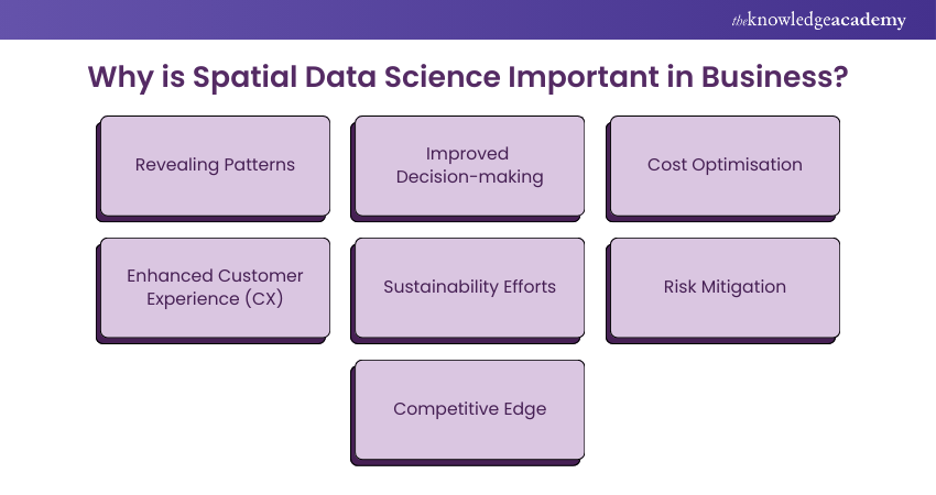
1) Revealing Patterns: Spatial data uncovers location-based trends, aiding retail, logistics, and real estate in making data-driven decisions.
2) Improved Decision-Making: It integrates predictive analytics to model future scenarios, enhancing marketing, supply chain, and operational strategies.
3) Cost Optimisation: Businesses save resources by streamlining routes, workforce allocation, and energy usage.
4) Enhanced Customer Experience (CX): Geospatial insights help tailor services, recommend nearby options, and predict demand.
5) Sustainability Efforts: Organisations use it to plan greener operations and monitor environmental impacts.
6) Risk Mitigation: Spatial data aids in fraud detection, disaster preparedness, and cybersecurity.
7) Competitive Edge: Companies like Uber and Deliveroo thrive by leveraging real-time geospatial insights.
By adopting Spatial Data Science, businesses unlock innovation, efficiency, and sustainable growth in an increasingly complex world.
Key Elements in Spatial Data Science
The following are the key elements of Spatial Data Science:
a) Data Engineering
Data engineering, a branch of computer science, involves managing the creation, storage, maintenance, use, and dissemination of data. Using programming tools like Python, SQL, and R, data engineers manipulate big data, ensuring it is ready for analysis. This is a crucial yet time-consuming aspect of data science. Data scientists prepare data by filling in missing values, adding fields, geoenriching, and cleansing values. Typically, the data science workflow begins with data engineering and the necessary ETL (Extract, Transform, Load) process.
b) Data Exploration and Visualisation
Data exploration and visualisation are critical facets of data science. By systematically exploring raw data, we gain a better understanding, which informs decision-making. Visualisation helps quickly identify patterns and relationships within big data, validating and ensuring the data makes sense. This process continues from start to finish: initially to understand the data, then to solve problems, and finally to share data insights with an audience.
c) Spatial Analysis
Spatial analysis, the core of GIS, involves examining the distribution of features in a geographic space. It addresses location-based problems by measuring, quantifying, and understanding spatial relationships and connections. Spatial analysis includes point locations, lines, polygons, rasters, and non-spatial attributes, enabling users to identify patterns like hot spots and analyse movements.
d) Machine Learning and AI
Machine learning involves teaching computers to learn without explicit programming, serving as a powerful tool in spatial analysis. It accelerates processes by analysing large data sets autonomously. For example, a machine learning classifier can accurately create land cover maps with minimal human input. As organisations collect, store, and analyse increasing amounts of data, machine learning has become an essential component of data science workflows, facilitating big data analysis and clustering.
e) Big Data Analytics
Big data analytics involves analysing large volumes of data to gain insights and make future decisions. It is applicable across various industries, including transportation, marketing, and retail. As the world digitises, the importance of big data analytics has grown, revolutionising many sectors. While it falls under spatial analysis, its main strength lies in analysing data at scale, regardless of whether the data consists of points, lines, polygons, or raster formats.
f) Modelling and Scripting
Automation, a long-standing method to reduce manual labour, allows for focusing on more critical tasks by creating repeatable workflows. In data science, automation connects data engineering to analytics, forming a self-functioning system. This operationalisation of analytics capabilities is a key part of ETL processes, which can run on varying schedules—daily, weekly, monthly, or yearly—depending on business needs.
Join our Data Science With R Training to gain in-depth knowledge and practical skills in R programming for data analysis!
Applications of Spatial Data Science
Spatial Data Science finds applications in a wide range of fields due to its ability to provide valuable insights into the spatial relationships and patterns within data. Here are some key applications:
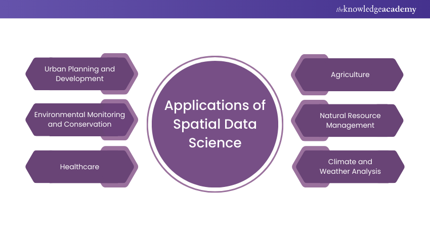
a) Urban Planning and Development: Spatial Data Science plays a crucial role in city planning by optimising infrastructure, land-use zoning, and transportation systems, contributing to the design of sustainable and efficient urban environments.
b) Environmental Monitoring and Conservation: Spatial data is vital for tracking ecosystem changes, monitoring wildlife habitats, assessing deforestation, and managing natural resources effectively, aiding in conservation efforts.
c) Healthcare: Spatial data helps map disease outbreaks, allocate healthcare resources, and analyse the accessibility of medical facilities, thereby enhancing public health planning and response.
d) Agriculture: Precision agriculture uses spatial data to optimise crop planting, irrigation, and pest control, increasing agricultural productivity and resource efficiency.
e) Natural Resource Management: Spatial analysis is essential for managing resources like water, forests, and minerals, ensuring their sustainable use and conservation.
f) Climate and Weather Analysis: Spatial data is employed to model and predict weather patterns and study climate change, aiding in disaster preparedness and long-term climate strategy.
Spatial Data Science Tools and Technologies
There are a variety of Spatial Data Science Tools and technologies to handle, analyse, and visualise spatial data effectively. Here are some key tools and technologies commonly used in this field:
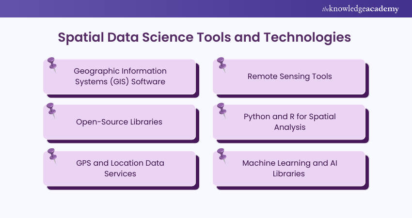
1) Geographic Information Systems (GIS) Software
Geographic Information Systems (GIS) software is the backbone of spatial data analysis. GIS platforms allow users to capture, store, analyse, and visualise spatial data in map form. Popular GIS tools like ArcGIS, QGIS, and MapInfo enable users to overlay multiple datasets, perform geostatistical analyses, and create compelling visualisations.
a) Use Cases: Urban planning, infrastructure development, environmental monitoring.
b) Features: Geocoding, spatial querying, and spatial data integration with business intelligence tools.
GIS software makes spatial data accessible and actionable, making it indispensable for governments, businesses, and researchers.
2) Remote Sensing Tools
Remote sensing tools utilise satellite or aerial imagery to collect data about the Earth's surface. These tools, including Google Earth Engine, ERDAS Imagine, and ENVI, help analyse large-scale environmental and geographical changes.
a) Applications: Land-use mapping, disaster management, and agricultural monitoring.
b) Technologies: LiDAR (Light Detection and Ranging), multispectral and hyperspectral imaging.
By offering a bird’s-eye view, remote sensing tools provide vital insights into areas that are otherwise difficult to access.
3) Open-Source Libraries
Open-source libraries offer cost-effective and highly customisable solutions for Spatial Data Science. These libraries provide frameworks and algorithms to handle geospatial data without relying on proprietary software. Some notable examples include:
a) GDAL/OGR: Geospatial Data Abstraction Library for raster and vector data processing.
b) Leaflet: An interactive JavaScript library for web-based map visualisations.
c) GeoPandas: Extends pandas for geospatial data manipulation and analysis.
These libraries are widely adopted in academia, startups, and industries for their flexibility and adaptability.
4) Python and R for Spatial Analysis
Python and R are dominant programming languages in data science, and their spatial analysis libraries make them indispensable in Spatial Data Science:
a) Python: Libraries like geopy, shapely, folium, and matplotlib enable data manipulation, geocoding, and visualisation.
b) R: Tools such as sf, raster, and tmap provide advanced spatial statistics and mapping capabilities.
These languages empower analysts to develop complex models, automate workflows, and integrate spatial data with machine learning and other analytical methods.
5) GPS and Location Data Services
Global Positioning System (GPS) and location data services are at the core of real-time spatial data collection. These technologies power navigation apps, logistics, and on-demand services by capturing precise geographic coordinates.
a) Examples: Google Maps API, Mapbox, and HERE Technologies.
b) Applications: Fleet tracking, route optimisation, and geofencing.
The integration of GPS data with spatial analysis provides dynamic insights into movement patterns and enhances operational efficiency.
6) Machine Learning and AI Libraries
Machine learning and AI libraries bring predictive power to Spatial Data Science. By combining spatial and non-spatial data, these tools enable automation and uncover deeper insights.
a) Python Libraries: TensorFlow, PyTorch, and Scikit-learn for spatial machine learning tasks.
b) Geospatial AI: Tools like H3 (Uber’s geospatial indexing system) and ML libraries in GIS software such as ArcGIS Pro.
These technologies facilitate tasks like hotspot detection, land-use prediction, and geospatial clustering, revolutionising industries like transportation, agriculture, and urban planning.
What Types of Data do Spatial Data Scientists Use?
Spatial Data Scientists utilise diverse datasets, combining internal, open, and premium data to build comprehensive, location-based insights.
1) Internal Organisational Data
a) CRM Data: Customer locations and purchasing behaviour.
b) Ecommerce & Delivery Records: Transaction and logistics data for route optimisation.
c) Call Detail Records (CDRs): Location-based telecommunication insights.
2) Publicly Available Open Data
a) Census Data: Demographics tied to regions.
b) Land Use & Environmental Data: Urban planning and sustainability metrics.
c) Transportation Networks: Infrastructure for mobility and planning.
3) Premium Spatial Data Streams
a) Human Mobility & Road Traffic: Foot traffic and congestion patterns.
b) Weather & Climate: Real-time and long-term environmental data.
c) Points of Interest (POI): Business and landmark locations.
d) Financial & Housing Data: Market trends and property insights.
By integrating these data types, spatial data scientists enrich analysis, enhance accuracy, and uncover actionable insights, helping businesses optimise operations, tailor strategies, and stay competitive.
Master data science concepts fast with the Data Science Cheat Sheet—grab it now!
How Spatial Data Science Different From GIS?
While GIS and Spatial Data Science both focus on spatial data, they differ in tools, scope, and applications.
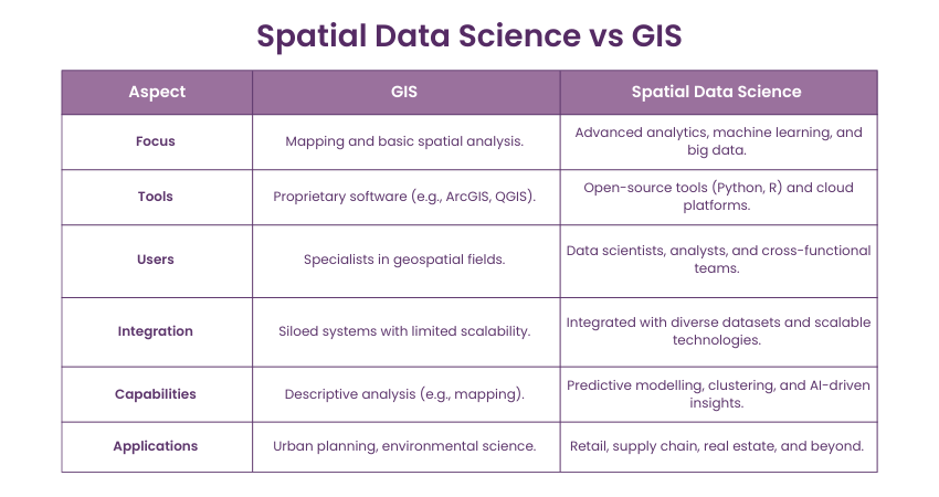
1) Scope: GIS primarily deals with storing, managing, and visualising geographic data through traditional tools like ArcGIS. Spatial Data Science integrates geospatial data with advanced analytics, machine learning, and big data.
2) Users: GIS is used by specialists in fields like urban planning and environmental science, often in siloed systems. Spatial Data Science attracts Data Scientists and analysts, fostering collaboration and broader applications.
3) Tools: GIS relies on proprietary software, while Spatial Data Science leverages open-source programming (Python, R), cloud technologies, and big data platforms.
4) Capabilities: GIS focuses on descriptive spatial analysis (e.g., mapping), while Spatial Data Science includes predictive modelling, machine learning, and integration with diverse datasets.
The rise of Spatial Data Science bridges traditional GIS with modern data science, unlocking scalable, innovative solutions for today’s complex spatial challenges.
Register for our Probability And Statistics For Data Science Training to unlock the key to making data-driven decisions with confidence!
Conclusion
In a world increasingly shaped by data, Spatial Data Science emerges as a crucial discipline, integrating geography, data analysis, and technology to examine the profound impact of location and space. With powerful tools like PySpark enabling large-scale data processing, this comprehensive guide has explored the fundamental aspects of Spatial Data Science, from its core concepts to its applications and the technologies that make it possible.
Join our comprehensive Data Science Training and equip yourself with the skills to make meaningful insights from data!
Frequently Asked Questions
What is an Example of Spatial Data?
Spatial data refers to information tied to specific locations. For example, a map showing the distribution of coffee shops in a city is spatial data. It includes geographic coordinates, addresses, and attributes like shop size or customer ratings, enabling location-based analysis and insights.
What Makes Spatial Data Unique?
Spatial data is unique because it includes geographic coordinates, enabling the analysis of location-based patterns and relationships. This geographic component allows for the visualisation and understanding of spatial phenomena, enhancing decision-making in various fields.
What are the Other Resources and Offers Provided by The Knowledge Academy?
The Knowledge Academy takes global learning to new heights, offering over 3,000 online courses across 490+ locations in 190+ countries. This expansive reach ensures accessibility and convenience for learners worldwide.
Alongside our diverse Online Course Catalogue, encompassing 19 major categories, we go the extra mile by providing a plethora of free educational Online Resources like News updates, Blogs, videos, webinars, and interview questions. Tailoring learning experiences further, professionals can maximise value with customisable Course Bundles of TKA.
What is The Knowledge Pass, and How Does it Work?
The Knowledge Academy’s Knowledge Pass, a prepaid voucher, adds another layer of flexibility, allowing course bookings over a 12-month period. Join us on a journey where education knows no bounds.
What are the Related Data Science Courses and Blogs Provided by The Knowledge Academy?
The Knowledge Academy offers various Data Science Courses including Text Mining, PySpark Training, Data Mining Training. These courses cater to different skill levels, providing comprehensive insights into data scientist salary.
Our Data, Analytics and AI Blogs cover a range of topics related to Data Science, offering valuable resources, best practices, and industry insights. Whether you are a beginner or looking to advance your knowledge of Data Science and Marketing, The Knowledge Academy's diverse courses and informative blogs have you covered.
Upcoming Data, Analytics & AI Resources Batches & Dates
Date
 Python Course
Python Course
Mon 26th May 2025
Python Course
Mon 28th Jul 2025
Python Course
Mon 22nd Sep 2025
Python Course
Mon 17th Nov 2025
 If you wish to make any changes to your course, please


